

Certerra Subsurface Liner Leak Location – Pinpointing industrial pond liner leaks
News2 Mar 2026
Our landfill characterization technology provides a non-invasive way to assess subsurface conditions associated with waste containment. We use advanced geophysical principles to reveal spatial boundaries, depth variations, and structural anomalies without disturbing the site. This approach transforms unknowns into actionable intelligence, offering clarity where records are incomplete or outdated, essential for managing sites where subsurface conditions may impact surrounding environments.
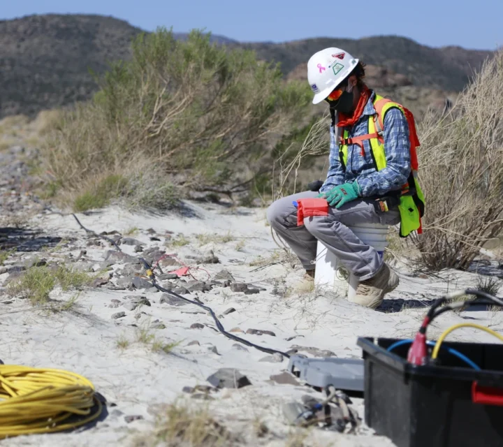
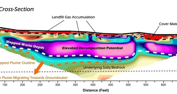
Our technology measures variations in physical properties such as conductivity, magnetism, and resistivity. We collect these measurements using specialized instruments that scan the ground surface. Differences in these properties reveal contrasts between natural soils, engineered covers, and buried waste materials. By combining multiple techniques with precise spatial control, we generate thematic maps that characterize subsurface waste boundaries, depth, and composition.
Uncertainty about what lies underground can lead to costly mistakes and environmental risks. Missing or inaccurate records make planning and monitoring difficult, while hidden changes in subsurface conditions can go unnoticed until they cause major issues.
Our technology addresses these challenges by providing accurate information about boundaries, depths, and material composition. It helps identify potential hazards, track changes over time, and reduce reliance on assumptions. This clarity supports better decisions and minimizes risks associated with unknown subsurface conditions.
We use multiple geophysical methods for landfill characterization. These non-invasive techniques map waste boundaries, identify buried materials, and assess cover integrity, providing the comprehensive subsurface data you need for site management, closure planning, and regulatory compliance.
Electrical resistivity measures variations in subsurface electrical properties to reveal differences in material composition.
Learn how landfill characterization works, why it matters, and how our geophysical methods help you map waste boundaries, assess site conditions, and make informed decisions for closure planning and environmental compliance.
Our equipment measures variations in physical properties like conductivity and resistivity using specialized sensors. These readings are processed into detailed maps and profiles of the subsurface.
You receive clear visualizations and data sets that reveal boundaries, depths, and material differences. These outputs support planning, monitoring, and long-term management strategies.
Yes. Because it’s non-invasive, repeated surveys can monitor trends and detect shifts in subsurface conditions, providing ongoing clarity and confidence.
Accurate subsurface data reduces uncertainty, prevents costly mistakes, and helps identify potential risks before they become problems. It ensures decisions are based on evidence, not assumptions.
Landfills often contain complex and undocumented subsurface conditions. Landfill characterization provides field-verified insight into waste extent and underlying features to support investigation planning, monitoring strategies, and informed subsurface decisions.
Loading...

